Both in land mass and in population, Belize is a tiny country, and to this it owes many of its charms. The entire population numbers only about 256,000, making it Central America's least populous country. The country is only 174 miles long and 68 miles wide (at its widest), which makes it approximately the same size as the state of Massachusetts. The people are friendly, open and relaxed - everyone there seems to know how to have a good time - and though tourism is big business, we never felt "commodified" or experienced any animosity from any of the locals. Everything we read, and other tourists we talked to, had the same comments about the people of Belize.
Belize embraces a beguiling mixture of Caribbean and Latin cultures, infused with a colonial history brought to its shores by early British settlers. Contrary to our initial belief, the country was never officially controlled by the Spanish, whose attempts to inhabit the area were warded off by the fierce Mayan people. The first British inhabitants were the Baymen (former pirates who raided Spanish ships carrying gold and silver from present-day Honduras and Mexico) who moved into the area hoping to make a fortune by pulling the valued logwood from the jungle forests. This practice also brought slavery to Belize as the Baymen began to discover that mining the logwood was much more labor-intensive than pirating. These slaves were brought into Belize from Africa via the Caribbean. Today, the culture consists mostly of descendants from the ancient Mayan and the logwood slaves. In 1871, Belize officially became a Crown colony under British rule, but was known as British Honduras. The first half of the 20th century was a difficult time in Belize, and misrule by the British led to the country's agitation for independence. When India gained independence in 1947, Belize focused on establishing Democratic institutions and political parties over the next few years and eventually self-government became a reality in 1962. In 1973, the name of the country was officially changed from British Honduras to Belize and on September 21, 1981, Belize officially became an independent nation, but it remains a member of the British Commonwealth.
Because of the British influence, English was made the country's official language, and nearly everyone speaks it flawlessly. Both Spanish and English are taught in the schools, but Creole appeared to be the "preferred" language of the locals. It was strange to listen to such a broken form of English, and understand roughly only 10% of the words!
The preservation of the country's many natural wonders is a high priority; some pioneers of the ecotravel movement actually started their work in Belize. Today, nearly 40% of the country is protected, either by national organizations or private trusts. In Cockscomb Basin Wildlife Sanctuary, Belize has one of the only jaguar reserves in the world. Ecotourism was practically born here, and in the jungle lodges throughout the region tourists can meet some of the pioneers of the sustainable tourism movement. Thanks to the Baymen, who used methods of selectively pulling logwood and mahogany from forests, clear-cutting practices never caught on in the country and vegetation that was less of a commodity was allowed to survive. Because the Baymen also relied on waterways to transport their logs, a road system never cleared the way for further settlement of the "bush", as the forest jungle is known, protecting the land. In fact even today there are very few roads through the country and of the roads that do exist very few are paved!
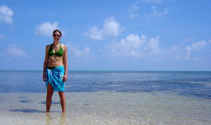
Belize is mainly tropical lowland. The country's Caribbean coastline and northern coastal plain are largely covered in mangrove swamp, which indistinctly defines the line between land and sea. Savannah surrounds the regions around Belize City. The south is thick with low-elevation sub-tropical forest. There are higher elevations in western Belize and in the Maya Mountains of the south. Offshore, the limestone bedrock extends eastward into the Caribbean for several miles at a depth of about 15 feet. At the eastern extent of this shelf is the longest barrier reef in the Western Hemisphere, the second longest in the world (behind Australia's) - at 180 miles! This reef provides the basis for tourism in Belize, and was the reason we chose to visit the country - it provides some of the best SCUBA diving in the world! :-)
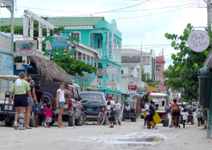
Kurt and I chose Ambergris Caye (pronounced 'key') as our home base while in Belize. This island lies 36 miles north of Belize City. It's about 25 miles long, and its northern side almost adjoins Mexican territory. In fact, it's believed that at one time the island was indeed connected to Mexico, but the Mayan dug out a passage to the Caribbean Sea that still exists today. There is only one town on the Ambergris Caye - San Pedro - located near the southern tip of the island. The barrier reef is only about 1/2 mile offshore from Ambergris, and the low bass roar of the surf breaking over the reef can be heard from nearly everywhere on the island. San Pedro has a very laid-back attitude, sandy streets, and few people who bother to wear shoes!
To reach San Pedro, Kurt and I flew into Belize City on the mainland. After going through customs and partaking in our first national beer - Belikin Beer - we boarded a flight aboard Tropic Air to San Pedro. The flight took all of 15 minutes, was never about 3000 feet, and was on a single prop plane that seated roughly 12 people. The view as we flew over the shallow turquoise waters to Ambergris Caye was fantastic! The only ways to reach our resort (Journey's End, north of San Pedro) was by golf cart (via a hand-pulled ferry across a boat channel) or by speedboat. No cars or trucks are allowed on the hand-pulled ferry, so there were no vehicles north of the town. The manager from Journey's End met us at the airport and took us to the resort's private speedboat and whisked us across the calm, clear waters to the resort, where we were met with a couple of nice, cold rum punches!
Since there were only a couple of hours of daylight left after checking in, we hopped in into an ocean kayak and paddled out to the reef to explore the marine life while snorkeling. To cap off the day, we dined by torchlight on the beach only inches from the water.
Day 1
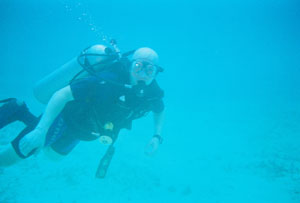
We spent the day Monday enjoying two reef dives just
minutes from our resort. The first dive of the day was in Hol Chan Marine
Reserve. Hol Chan is Mayan for 'little channel' and it was the first marine
reserve established in Central America. The park encompasses about 5 sq
miles of protected area, dotted with coral formations, at depths to 30
feet.
 |
|
Reef Dive (Click
for More Pictures)
|
Our afternoon dive was directly offshore from our resort at an area known as "El Pescador". This site also provided beautiful corals and tons of marine life, but the depths were up to 80 feet. There were also many 'swim-throughs' - deep canyons surrounded by towering coral formations - that led into narrow passages between and under the coral formations. We also spied several stingrays buried on the sandy bottoms, as well as a 14-16 inch sea turtle that wanted to play with us!
Day 2
This was our big diving day! A boat picked us up on our dock at 5:30am and by 6:30 we were on a speedboat out to Lighthouse Reef Atoll. The agenda for the day was to dive the famed Blue Hole.
There are 3 main atolls in Belizean waters: Lighthouse Reef Atoll (mentioned above) Turneffe Atoll and Glover's Reef. All lie outside the barrier reef and feature oblong rings of coral surrounded by shallow turquoise lagoons and punctuated by sandy mounds topped with coconut trees. They developed from chunks of earth that at one time were attached to the mainland. As they slide into the sea, corals keep growing and building their structure around them. The outer edges of the atolls have coral walls that plunge thousands of feet.
Lighthouse Reef is about 50 miles southeast of Belize
City, and takes approximately 2 and a half hours to reach from San Pedro.
In the center of the atoll is the most famous site in this area, the Blue
Hole. Almost perfectly cylindrical, the Blue Hole measures 1000 feet across
and 480 feet deep. Two narrow channels lead inside. The Hole itself is
the opening to a system of caves and passageways that penetrate this submerged
mountain. Inside is a beautiful cathedral of huge stalactites formed thousands
of years ago before the end of the last Ice Age when this was a subterranean
cave. When the ice melted, the sea level rose, flooding the caves. The
stalactites range from 20 to 60 feet in length and drop from the "roof"
of the cavern.
 |
|
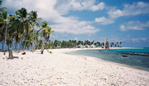
Half Moon Caye (Click
for More Pictures)
|
The Blue Hole dive was our first for the day. Our Dive Master gave us an extensive 'briefing' (what to do, what not to do) and then led us into the clear, blue water. This is an extremely advanced dive, as we descended to a depth of 130 feet. After entering the water, we had 3 minutes to descend to this incredible depth, passing sheer walls until we reached 110 feet, where the stalactites begin. Once at 130 feet, we had 5 minutes to swim under what's left of the cave's roof and weave between the gargantuan stalactites. We then started our slow ascent to the surface - which took us 14 minutes. At one point, Kurt and I noticed a school of big Black Tip Reef Sharks (about 8 or 10) circling slowly 20 or 25 feet below us. What an incredibly eerie sight!
Our second dive of the day was the Wall at Half Moon Caye. This was our first wall dive, and we will be spoiled for all future ones! Similar to our second dive on Day 1, our Dive Master first led us through narrow coral canyons with towering coral mountains on both sides. Contrary to the previous day, this swim-through did not end in a dark tunnel under the coral but instead opened onto the wall itself, the bottom dropping out from under us to depths of thousands of feet with nothing visible other than the gorgeous cobalt blue abyss. The experience was breath taking.
These 2 dives certainly worked up an appetite for us, so our dive company provided lunch on the island of Half Moon Caye. This island has to be the most tropical setting we have ever set foot on, only white sand, piles of gigantic sun-bleached seashells, and swaying coconut palm trees. After eating a traditional lunch of barbequed chicken, cole slaw and rice and beans (with hot sauce), we set out on a short hike to the Booby Bird Sanctuary. Some 4000 rare red-footed boobies call this island home, along with the magnificent frigate bird and 98 other bird species. The hike led us through lush vegetation to an observation platform that brought us to eye level with the nesting boobies and frigate birds. Along the path we saw thousands of seashells, many inhabited by hermit crabs.
The 3rd dive of the day was at Long Caye, also in the Lighthouse Reef Atoll. There were so many fish at this site that we nearly had to push them out of the way in order to swim! Kurt and I were astonished at the size of the purple barrel sponges at this site - nearly large enough for one of us to climb inside! Again, the wall at this site provided a marvelous drop into the bottomless blue expanse, where we saw the occasional lone shark perusing the depths below us.
Day 3
Wednesday was our first trip to the mainland since arriving in Belize; a trek to the Mayan ruins known as Lamanai. The journey to Lamanai was as much of an adventure as exploring the old ruins. Once again, a speedboat picked us up from our dock about 6:30am, and after picking up a few additional people at various resorts on the island, we headed across the water towards the mainland. The boat ride across the open water was approximately 40 minutes and culminated at the mouth of the Northern River, north of Belize City. Our boat journey continued up this river, through beautifully lush mangrove jungles (and a little rain as well), until we reached the tiny Bomba Village. After a few minutes to browse through the handful of local craft shops in Bomba, we climbed aboard a van and set out on the "road" towards the Old Northern Highway (locally called the Old Pan American Highway).
The bumpy, pot-holed-filled, sand road made the trip seem to last a couple of hours, although we probably made it to our next boat (on the New River) within 45 minutes or so. We boarded our new boat and set out through the jungle for Lamanai. Along the way we passed the village of Shipyard, a large Mennonite settlement (yes, Mennonite). Mennonites represent a small but influential group in Belize. While they keep to themselves in settlements, they provide most of the food consumed in the country. After a 25-mile journey upriver, the water widened into a sprawling lagoon, and we spied the stone tip of a giant temple peeking above the tops of the jungle foliage.
 |
|
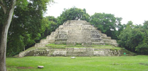
Lamanai (Click
for More Pictures)
|
The ruins at Lamanai are perhaps the most impressive in Belize. Lamanai is one of the only a few sites whose original Maya name - Lamanyan - is known; it translates as "Submerged Crocodile", hence the numerous representations of crocodiles. Lamanai, however, the seventeenth-century mistransliteration, actually means "Drowned Insect". The sites was continually occupied from around 500 BC up until the sixteenth century, when Spanish missionaries built a church alongside to lure the Indians from their heathen ways. Teams of archeologists have mapped more than seven hundred structures, the majority of them still buried beneath mounds of earth.
Seven troops of black howler monkeys make Lamanai their home, and we saw (and heard) at least 2 of those troops during our trek through the forest! The Temple of the Masks, the Temple of the Jaguar, the Royal (Ball) Court, and Stela 9 were all interesting stops during our hike but the most intriguing and impressive ruin was El Castillo (The Castle). This is the tallest Preclassic structure in Belize, standing 112 feet above the jungle floor. This was also the only ruin we were allowed to climb, and it was definitely a challenge! Not quite as difficult as climbing Mt. Everest, but certainly almost as steep! J
Once again, we were served a lunch of chicken (stewed this time), potato salad, rice and beans, pineapple and fresh tortillas. Oh… and a "salsa" that had quite a bit of kick: chopped onions and habaneros complete with the seeds! Belizeans certainly enjoy their habaneros!
Day 4
After allowing the morning rain to pass, Kurt and I rented a couple of beach bicycles. Once we'd remembered how to use the coaster breaks, we set out on the Beach Path towards town, returning waves to the local workers on the way. The path led us to the hand-pulled ferry for a ride across the water into town. Once in town, we spent the day exploring the sandy streets and souvenir shops. We occasionally refreshing ourselves with a Belikin in a beach bar while watching the surf break on the reef just offshore. We ran into "rush hour" on the way home; troops of locals returning from work (by bicycle, of course) on the northern part of the island.
 |
|
Lamanai (Click
for More Pictures)
|
Day 5
Our last day in Belize took us to the mainland once again, this time to the Belize Zoo and to St. Herman's for a little cave tubing adventure.
The speedboat picked us up from our dock at about 6:30am (remember, we were on island time - so everything was about 15 minutes late!) and headed out across the water towards Belize City and the mouth of the Belize River. This time our cruise up the river was not nearly as far, but we did have the opportunity to see many iguanas and birds sunning themselves in tree branches on the riverbanks. In Ladyville (basically a suburb of Belize City), we disembarked from the boat and climbed aboard a bus. (Ironically, the bus displayed signs of having spent a former life as a school bus in Thomas County, KS!!)
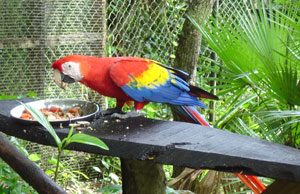
Our first stop was the Belize Zoo, located on the Western Highway (which runs between Belize City and the present-day capitol of Belmopan) approximately 30 miles inland from Belize City. When a documentary film entitled "Path of the Raingods" was shot in Belize, Sharon Matola was hired to take care of the animals. By the time filming was over, the animals had become partly tame and Matola was left wondering what to do with her 17 semi-wild charges, knowing they were unlikely to survive if released back into the jungle. In 1983, Matola founded this zoo, which displays native Belizean wildlife in natural surroundings on 29 acres of tropical savannah. There are now more than 125 native animals, including jaguars, ocelots, black howler monkeys, peccaries, vultures, storks, crocodiles, tapirs and gibnuts. One of the zoo's central goals is to make Belizeans sensitive to the value of preserving native wildlife. Our day's tour guide seemed to know exactly where the animals like to hide, and he could also imitate the black howler monkeys perfectly. Black howler monkeys will answer your call if you can make it life-like enough, and WOW are they loud and scary sounding!
 |
|
Belize Zoo (Click
for More Pictures)
|
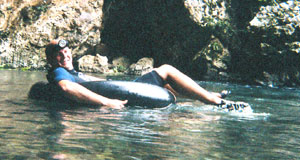
We piled back into the bus and continued our trek along the Western Highway, catching a cut-off to the Hummingbird Highway. This road runs southeast out of Belmopan, along the edge of the mountainous area. Eventually we arrived at St. Herman's Cave on the Cave Branch River. The first order of business was to partake in lunch at an exquisite restaurant buried in the jungle. (Guess what we had? That's right! Stewed chicken, rice and beans and cole slaw... and don't forget the hot sauce!)
As soon as lunch was over, we donned our wetsuits, hefted our inner tubes on our shoulders, and grabbed headlamps. Kurt and I were the only ones with wetsuits, and we received much grief for this, but the water was only 70 degrees! Our guides led us down a mountain path, buried deep in the jungle foliage. When we arrived at our inner tube put-in spot, we tossed in our tubes and jumped the 15-foot cliff into the clear, turquoise water below. The river immediately slipped inside the looming mouth of the cave, and away we floated. After floating into the first cave several hundred yards, we rounded a corner and could no longer see the opening through which we had come. Our guide instructed us to turn out our headlamps, and WOW was it dark! We cruised along in the dark for a good 10 or 15 minutes before we emerged into a spectacularly lush green landscape and bounced over a few small rapids before entering the mouth of the second cave.
 |
|
Cave Tubing (Click
for More Pictures)
|
The second cave was really more spectacular that the first. It was larger, with many more stalactites and crystals hanging from the ceiling. We even encountered a gorgeous waterfall within the dark confines of the cave. Eventually, our ride came to an end and Kurt and I were extremely glad we'd worn our wetsuits, it was chilly! We dried off, boarded the bus back to Belize City and were thankful the Hummingbird and Western Highways were MUCH better than the Old Northern Highway.
Day 6
Following a tasty breakfast of fresh fruit and Johnnycakes at Journey's End, Kurt and I boarded a speedboat for the last time and headed to the airport in San Pedro. With the initial shock of arrival over, we were able to analyze the San Pedro airport for what it really was: a barely-paved runway with a couple of small buildings sitting alongside it. There was no security, and you could even walk on the runway itself as long as there wasn't a plane visibly in a landing pattern.
 |
|
Resort and Travel (Click
for More Pictures)
|
As we boarded our small single-engine plane, the pilot invited Kurt to sit co-pilot for the ride! Thankfully, he didn't have to assist - we hadn't stayed at a Holiday Inn Express in days! :-)
After checking into our airline in Belize City, we finished a last bit of shopping, then boarded our flight back to reality.